

ICESat-2 at UT Austin
NASA’s state of the art photon-counting laser altimeter has been providing global elevation measurements since 2018. UT Austin has one of the largest external research footprints with capabilities in operational support, mission design and science discoveries.
ICESat-2 for Earth Science
Satellite altimetry systems keep an eye on Earth’s environment from space, monitoring changes in the heights of ice sheets, glaciers, and forest canopies to record the effects of a changing climate. One such system, NASA’s Ice, Cloud, and land Elevation Satellite 2 (ICESat-2), was launched successfully on 15 September 2018, and is currently collecting critical measurements of the Earth system.
The cutting-edge lidar technology aboard ICESat-2 is optimized for the polar regions, where observations help researchers evaluate the current state of our ice sheets and sea ice. The satellite’s global coverage also delivers high-resolution measurements of tree heights, inland water reservoirs, cloud characteristics, and oceans, improving our knowledge of biomass estimates, water storage, atmospheric heat flux, and sea level. Since ICESat-2’s launch, data not only have met expectations but also provide a window into other potentially transformational science discoveries.
The efforts in research and development associated with ICESat-2 at UT Austin support a broad range of technical applications and analysis. The team has been involved since 2014 in the mission concept development and implementation studies. We have worked on the airborne simulator for ICESat-2 and designed critical validation strategies to ensure the data quality once on-orbit.
Earth Observing Active Remote Sensing analysis and application
-

Bathymetry from Space
One of the most transformative capabilities of ICESat-2 is the ability of the laser to penetrate water and measure the sea floor depth in shallow water conditions. 3DGL is tasked by NASA to provide a new along-track algorithm that automates the extraction of the bathymetric retrievals and investigates how the environmental conditions (sea state, water clarity, etc.) influence the performance of a space-based bathymeter 300 miles away! In collaboration with Oregon State University, Dr. Magruder’s team will be creating a new ICESat-2 along-track mission product for the community in the coming year.
-

Satellite data validation.
3DGL provides innovative ways to validate the quality of the laser altimetry measurements. Small optical components are place along the satellite ground track and provide a unique signal signature back to the spacecraft. These signatures give an independent value for the location of the laser footprint at the surface of the Earth. The comparison ensures that the mission is meeting its requirements.
-

Mission operational and science support
UT Austin supports the operational precision pointing determination effort for the ICESat-2 mission- one of the most critical components to accurate measuring Earth elevations from space. Additionally, Dr. Magruder served as the ICESat-2 Science Definition Team Leader during pre-launch mission development and the Science Team Leader for a total of 10 years.
-
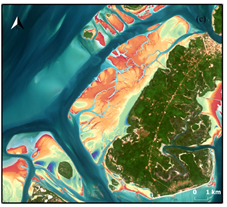
Spatial-temporal shoreline variability with space-based observations
This research hopes to fill the coastal change timeseries gap by building and evaluating a complete toolkit for fusing space-borne passive (multispectral satellite imagery) and active (laser altimetry) data for coastal science applications. Specifically, this research will combine 2-dimensional shorelines derived from imagery with altimetry elevation data to create 3-dimensional shoreline geometries spanning a five-year period. These shorelines will then be aggregated and their seasonal change will be assessed and validated against known water levels.
-

ICESat-2 as a correction strategy for other space-based data products
Large area digital terrain models (DTMs) are crucial for many geospatial applications. Spaceborne Synthetic Aperture Radar (SAR) platforms are often used to create these DTMs as they provide an effective tool to collect surface elevations across a wide extent. However, SAR-derived DTMs do not accurately measure ground elevations in the presence of forests. However, ICESat-2 can provide the data via AI/ML mechanisms as a correction strategy for a more accurate and effective DTM data product.